In this article we review the process to align the reported Base Station ECEF locations for a network of six stations to all use a common IGS08 frame of reference. This is commonly necessary when the stations are managed by other parties who have selected another datum for use. The SNIP Caster provides the ability to adjust the location of any Base Station by using the PFAT Translation ECEF Adjustment feature.
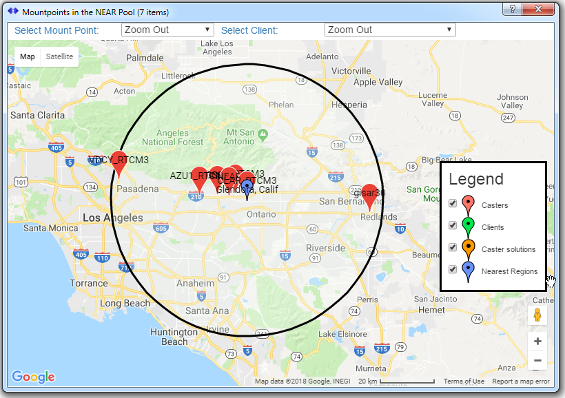
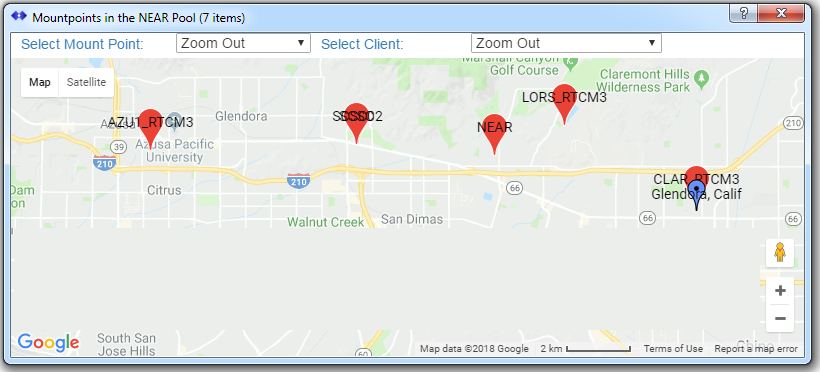
The motivation for this adjustment was to create a NEAR style mountPt for use in vehicular testing along an East-West Freeway (I-210). The Base Stations used consisted of two stations operate by SCSC at their offices, one by ESRI, and three operated by UNAVCO. Here is view of resulting NEAR mountPt members, and a closer view of the I-210 freeway test area used. [Click to enlarge]
Preliminaries
The first step in this process is to a) decide what reference frame to use and b) to obtain what a reliable tool states are the precise (0.01 mm) Base Station locations in that reference frame. First collect suitable data (typically many hours of representative data logged by SNIP and then decimated to ~15 second observations). It is then submitted to OPUS and you await the results by email (often <30 minutes). Other tools can also be used. See the attached file at the bottom of the page for the results which we obtained and then used here.
A typical set of returned values looks like this. The three key values to be entered are shown in bold (SNIP will convert this to the precise LLH and display it as the values are entered).
gisar30  FILE: gisar30_180208.obs OP1518208963750
RINEX FILE: gisa0390.18o                            TIME: 20:45:11 UTC

REF FRAME: NAD_83(2011)(EPOCH:2010.0000)              IGS08 (EPOCH:2018.1055)
         X:     -2419200.246(m)   0.007(m)          -2419201.201(m)   0.007(m)
         Y:     -4703567.059(m)   0.007(m)          -4703565.589(m)   0.007(m)
         Z:      3553009.457(m)   0.010(m)           3553009.447(m)   0.010(m)

       LAT:   34  4  9.47467      0.006(m)        34  4  9.49022      0.006(m)
     E LON:  242 46 54.26825      0.005(m)       242 46 54.20892      0.005(m)
     W LON:  117 13  5.73175      0.005(m)       117 13  5.79108      0.005(m)
    EL HGT:          344.251(m)   0.010(m)               343.524(m)   0.010(m)
 ORTHO HGT:          376.983(m)   0.018(m) [ H = h-N (N = GEOID12B HGT)]
Adjusting each Base Station
The PFAT Translation ECEF Adjustment dialog is brought up for each stream (see the general Translation Dialog which then allows starting the ECEF Adjustment Dialog). The desired ECEF coordinates are copied into the corresponding three places in the dialog along with any additional Antenna offset height above a known monument, and any ITRF realization year. This is shown by the red highlights below:
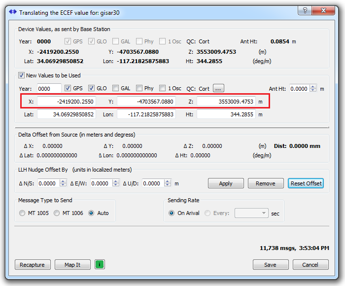
The Recapture and Reset buttons have been pressed in the above image, so no new offset value is yet present.
Some older GNSS devices may not set the GPS or GLO check boxes correctly (used to indicate that this type of observation is present). This can be corrected by setting the box when needed. The Phy box is normally checked ONLY when the Base Station is not a physical device (the logic here is backwards from what you might expect). See this article on the the dialog control widget for further details. (link to be provided)
Two best practices items should be noted and observed.
Note: The “ITRF realization year” is left as “0000” in almost all cases. The RTCM SC_104 has never determined how this should be properly used. Our original intent was to use it as a means to declare the frame of reference that was being used for the coordinate (and thereby enable the rove to apply ground velocities and other transformations if desired). This never really caught on and in fact many more frames of reference have come to exist than simply annually updated WGS-84 based ones. At this point it is best to leave it all zeros (officially this is still a reserved value), but SNIP will allow you to enter a number.
Note: The Antenna height value is used to represent the vertical distance between a marker / monument and the antenna reference point (ARP), which is a physical mark on the antenna, and not normally at the same height as its L1 phase center. If you have used OPUS or another similar service, the returned results already incorporate any height and phase center issues. So there is no need to enter them here.
The difference between MT1005 and MT1006 is simply that MT1006 uses an additional 3 bytes to convey Antenna height. If the height is set to zero, and the Message Type to Send is set to “Auto” then SNIP will use MT1005 when there is no height present, unless you tell it to use MT1006.
This process is repeated for every Base Station that needs to be aligned.
The Result
As these values are added to each stream, the dialog, and then the SNIP console, reports the resulting offset that is created between the old datum and the new.
[AZU1_RTCM3]:  Translate Active, Base Station has been offset by 49.1603 cm
[CLAR_RTCM3]:  Translate Active, Base Station has been offset by 15.7102 cm
[SCSC]:        Translate Active, Base Station has been offset by 1.1349 m
[SCSC02]:      Translate Active, Base Station has been offset by 1.1303 m
[gisar30]:     Translate Active, Base Station has been offset by 1.7728 m
[VDCY_RTCM3]:  Translate Active, Base Station has been offset by 49.2517 cm
Once added, the new values are used whenever the stream is active. The entire translate process can be disabled, or the ECEF Adjustment can be disabled, both by unchecking the appropriate check boxes in their dialogs. In the dialog above, the check box marked New Value to be Used disables the ECEF Adjustment when not checked.
A Supporting Data File
The ECEF values returned by OPUS for this use are found in the attached file, as well as the original ECEF Base Station values being send. The final value are also shown, both decoded by SNIP. As a best practice, developing a similar set of data for the network of interest before starting to edit is advised.
OPUSresults as a PDF
See Also
- PFAT Filter; used for Filtering message types from a data stream
- PFAT Add; used for Adding message types to a data stream
- PFAT Trans; used for Translating message in a data stream (the general dialog for translate)