
This page addresses common questions asked by the
Survey and Machine Control Communities about the SNIP NTRIP Caster.
Background
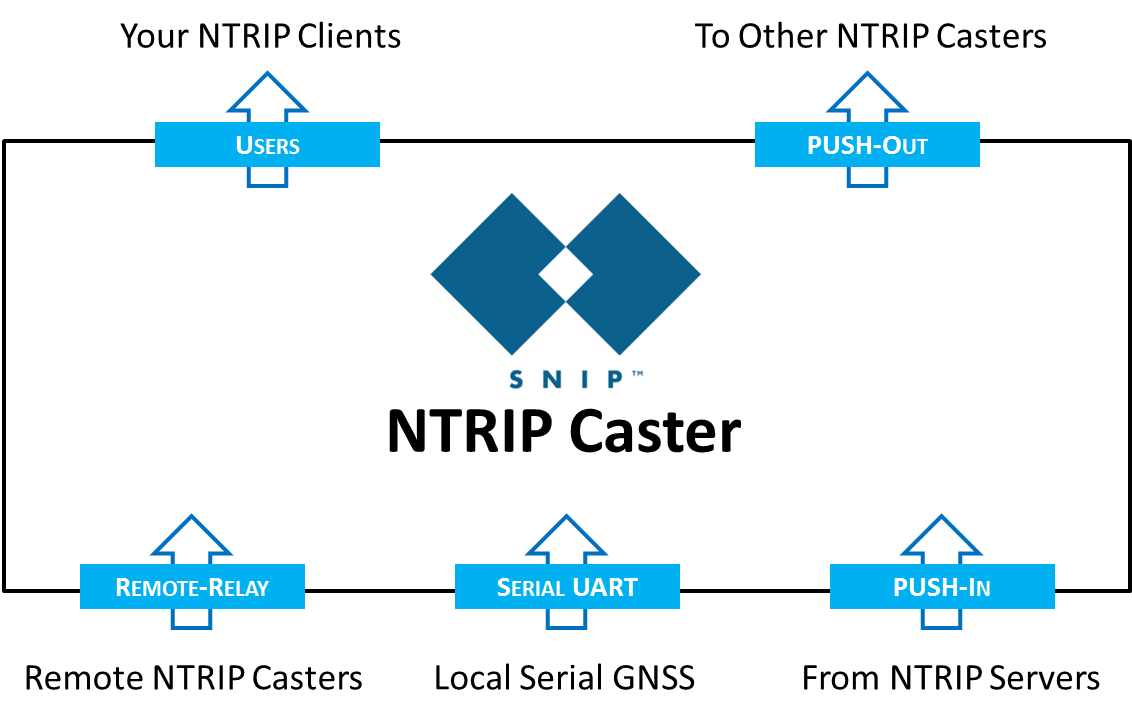
SNIP is a classic NTRIP Caster design used to connect your rover devices (NTRIP Clients) to your Base Stations (NTRIP Servers). You can use it to connect as many end users as you wish to your Base Station(s) for their RTK data needs. SNIP runs on any Windows system from Win7 onward. And no server is required, that’s right – it does not require a server OS to run. It also does not require a static IP (you can use DDNS or RTK2go.com if needed) It can transport RTCM 3.x, RTCM 2.x, CMR/CMR+ and a wide number of other message formats. It handles all GNSS signal types (GPS, GLONASS, Galileo, QZSS, BeiDou and SBAS). It provides a rich set of additional features to help the owner / operator monitor the performance of his stations and users. And like all SNIP models, it is very affordable.
SNIP is available in three models; Lite, Basic, and Pro.
A downloadable Evaluation model allows full-featured trial use.
Basic, For Survey Use
SNIP Basic is the ideal NTRIP Caster for the needs of small Survey Teams. An NTRIP Caster equipped with features normal only found in Caster systems costing ten of thousands of dollars. It contains all of the core features found in the popular Lite version, plus
- The ability to run and monitor up to 8 Base Stations (and more can be added)
- Connect older pre-NTRIP equipped GNSS devices with a direct RAW/TCP feature
- Perform various PFAT translations such as datum shifts and alignments – be ready for 2022 today !
- Can Operate a NEAR pool stream for closest single base line use
- Capture and log each Base Station 24/7 with FTP storage for post processing use
- Much less $$$ than any alternative solution from the big boys
SNIP Basic models (as well as Pro and Lite models) are deployed by surveyors all over the world. Some run their networks 24/7, while other operate only during field campaigns. In the three years since SNIP was introduced, it has quickly become the most popular NTRIP Caster out there.
Paying the big boys nearly $1k/yr for each piece of equipment you operate? Suddenly the Basic or Pro models of SNIP are a near instant return on investment for you.
Typical Use Case
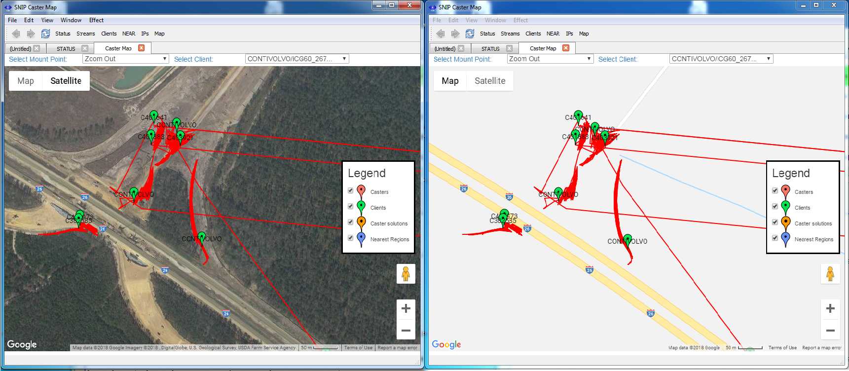
Below is a typical example where SNIP has been employed (with large ROI due to the savings) on a short term construction job site. This is a long term construction site. The basic mission is to support several equipped devices doing earth moving and precision grading for a new freeway entrance in South Carolina. The Base Station is attached to the job site trailer and precisely located in the normal way, its ECEF location is shown as the red point at the lower right. The operational area is about one km away from the Base.
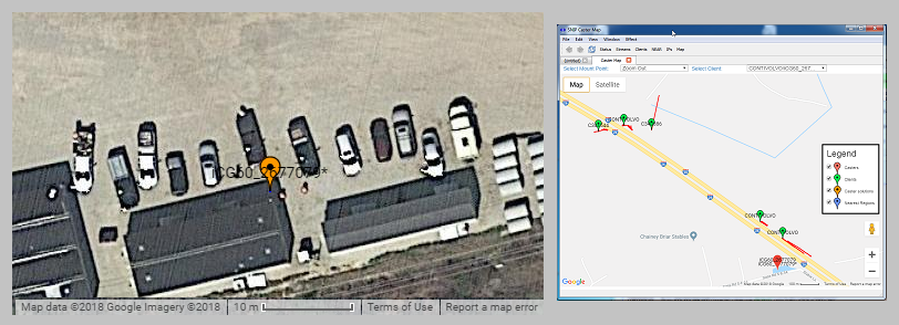
The images below (taken from SNIP‘s document viewer tools) shows several rovers moving earth on both a roadway base map and a satellite view base map. The plot positions were taken from the NMEA $GGA sentences sent by each rover device back to the Caster. [Data captured Sept. 21st 2018 from Conti Professional Services operated devices, used with permission.]
Still using Radios?
If you have cellular coverage where you work, drop the radios, grab a cell phone, and go with NTRIP. There are still many places in the world, however, that do not enjoy such coverage. And in these places, a radio often remains the best solution. [Many of our users in central Africa use satellite phones!] Many of the more modern radio designs employ a TCP/IP connection layer, and SNIP works with these as well. This is a technology area that is growing with the Precision Ag user community.
Mixed Datums?
If your operating region and users need corrections in multiple horizontal or vertical datums, SNIP has you covered. The Basic and Pro models allow you to send the same data stream with different ECEF messages to support each datum using SNIPs unique PFAT features.
Annual Fees?
None. Other than for some optional 24/7 monitoring services, there is no reoccurring fees to own SNIP.
Will it work with my Equipment?
If the device does RTK, and uses RTCM SC-104 message (as 99.9% of such devices do), the answer is yes.
A Few Survey and Precision Earth moving Firms Using SNIP include


If NTRIP will be a part of your tool set, you need to take a look at SNIP today.
Try out SNIP features using our free evaluation download.